by Jim Berg, Minnesota Department of Natural Resources
Introduction
For well owners in southwestern Minnesota who are concerned about their water quality and associated health risks – geology matters. The buried sand and sandstone aquifers that are typical of this area are generally protected from surface contamination but that hydraulic isolation leads to groundwater with elevated concentrations of naturally (geologic) occurring elements, such as arsenic and boron, that can be a risk to human health.
Examples are shown from the newly published Redwood and Brown county groundwater atlases. Both of these atlases are available online or as paper copies. Typical of all Part B groundwater atlases, these reports look at a wide range of groundwater characteristics and conditions in the county. Topics include water-table elevation and depth; residence-time indicators (tritium and carbon-14); groundwater and surface-water interaction, and inorganic chemistry distribution (chloride, nitrate, arsenic, and boron). Additionally, the report includes maps of pollution sensitivity, potentiometric surface and groundwater flow, and hydrogeologic cross sections.
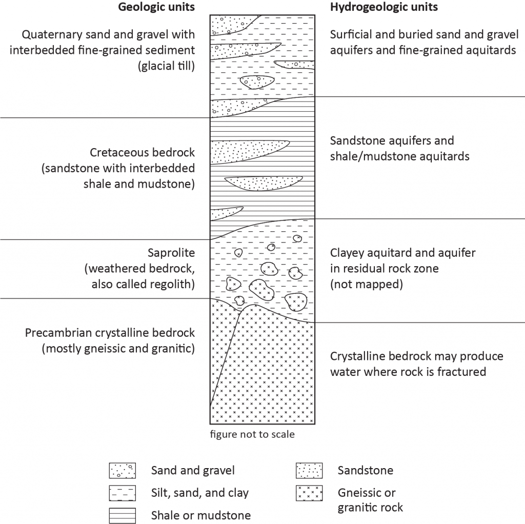
Redwood and Brown are adjacent counties located in southwestern Minnesota along the Minnesota River. Both counties have a similar general geology and hydrogeology with multiple layers of sand and gravel aquifers and glacial till aquitards overlying Cretaceous sandstone aquifers and interbedded shale aquitards (Figure 1). The Cretaceous bedrock is thin or absent in the northeastern portions of both counties. In the far eastern portion of Brown County the Cretaceous bedrock is underlain by the eroded edge of Cambrian sandstone and shale formations not shown in Figure 1.
Because of the similar geology and hydrogeology of both counties, we have been able to display some county maps together in this article to illustrate distinctive geochemical trends for arsenic and boron that apply to both counties.

Selected groundwater chemical characteristics
One of the goals of the groundwater atlas program is to map select water chemistry that can indicate areas where groundwater consumption is a potential concern to human health. A total of 265 groundwater samples were available for this analysis. Samples collected for these atlas projects were mostly from domestic wells in 2017. These data were combined with existing data from DNR and Minnesota Department of Health databases. Examples of arsenic and boron distribution are featured in this article. Other chemical evaluations include in the atlases include other trace constituents, major cations and anions, residence time indicators, and stable isotopes of hydrogen and oxygen.
Arsenic
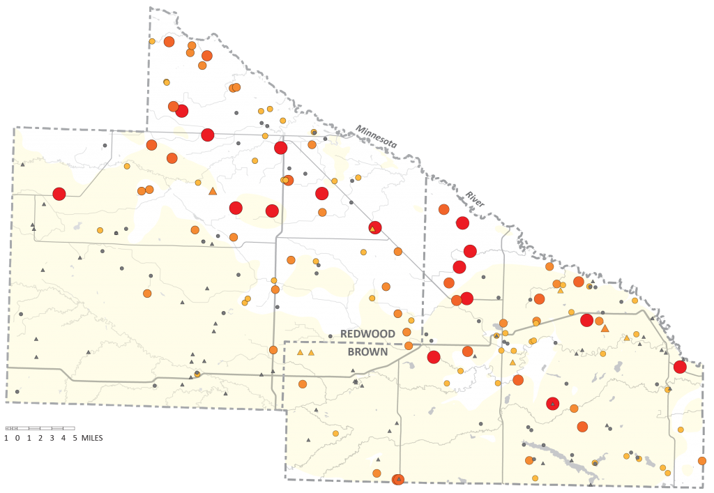
Arsenicis a naturally occurring element that has been linked to negative health effects, including cancer. If arsenic is indicated at any level, the MDH advises domestic well owners to treat drinking water. Elevated arsenic is characteristic of the buried sand aquifers in the area and to a lesser extent Cretaceous sandstone aquifers. Since the use of the buried sand aquifers is more common in the northeastern portions of Redwood and Brown counties, elevated arsenic is more common in that area (Figure 2).


The factors affecting elevated arsenic concentrations in groundwater are not completely understood. There is a strong correlation with glacial sediment derived from rocks northwest of Minnesota. High arsenic concentrations are believed to be caused by naturally occurring, arsenic-bearing minerals associated with small shale particles in these tills (Erickson and Barnes, 2005).
Boron
Boron is a naturally occurring element that has been linked to negative health effects. The Minnesota Department of Health (MDH) developed risk assessment advice (RAA) for boron in drinking water at 500 ppb. In animal studies, exposure to high levels of boron caused decreased fetal weight and improper fetal development, as well as disruption to the male reproductive system. MDH’s guidance value of 500 ppb is designed to be protective of formula-fed infants, who may ingest more boron from food and water, on a per body weight basis, than older children or adults. A person drinking water at or below the guidance value would be at little or no risk for harmful health effects.
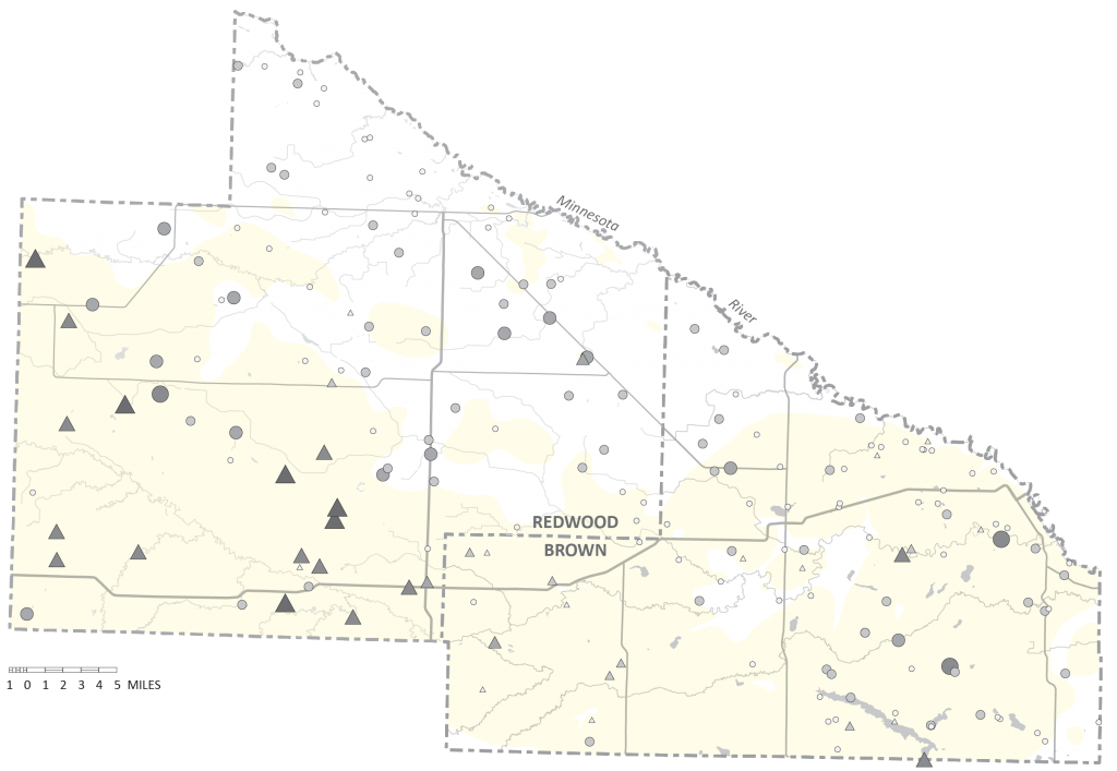
In this area, especially in Redwood County, there appears to be a strong association of elevated boron and Cretaceous aquifers and to a lesser extent the buried sand aquifers. Elevated boron concentrations in Minnesota groundwater are not common. In the Geologic Atlas of Pine County, Part B (Berg, 2004), elevated concentrations of boron in groundwater samples were found in the eastern part of the county. These groundwater samples were from fractured basaltic rocks created during the midcontinent rift episode. The ultimate mineral or fluid sources were never identified but a positive correlation with groundwater residence time was shown (the older samples had higher boron concentrations) suggesting the older waters were less diluted by more recent recharge. Both the Redwood and Brown county groundwater atlas show that most of the longest carbon 14 groundwater residence times (11,000 to >40,000 years) in the area are from the Cretaceous sandstone aquifers.
The strong correlation of higher boron concentrations and Cretaceous sandstone groundwater suggests the presence of boron-rich parent material (MPCA, 1998) A major source of boron from borax in the world is non-marine evaporate deposits. Possibly there is some unknown association of these types of deposits and the marginal marine Cretaceous bedrock of southwestern Minnesota.


Summary
Elevated arsenic and boron concentrations are strongly associatied with northwestern sourced glacial sediment and Cretaceous shale and sandstone, repectively, in hydraulically isolated settings. The good news for well owners and government regulators is that groundwater from these units is typically protected from anthropogenic contaminants. The bad news — aquifers in these settings can contain trace elements that may pose human health risks. Knowing which natural contaminant is most likely in this region depends largely on the geologic origins of the aquifer and surrounding aquitard material.
References
Berg, J.A., 2004, Pine County Geologic Atlas, C-13, Part B,
https://www.dnr.state.mn.us/waters/programs/gw_section/mapping/platesum/pinecga.html
Erickson, M.L., and Barnes, R.J., 2005, Glacial sediment causing regional-scale elevated arsenic in drinking water: Ground Water, November–December, v. 43, no. 6, p. 796–805.
Minnesota Pollution Control Agency, 1998, Baseline Water Quality of Minnesota’s Principal Aquifers – Region 4, Southwest Minnesota, Ground Water Monitoring and Assessment Program (GWMAP). P. 18-22.
For more information:
Contact Jim Berg, hydrogeologist (651-259-5680, jim.a.berg@state.mn.us) of Paul Putzier, supervisor (651-259-5692, Paul.putzier@state.mn.us)
Website: mndnr.gov/groundwatermapping
MGWA is committed to developing a just, equitable, and inclusive groundwater community. Click on the button below to read MGWA’s full diversity statement.