By Greg Brick, Ph.D.
Introduction
Among Minnesota bottle collectors and residents of the Highland Park neighborhood of St. Paul, the story of the Highland Spring Water Company, at Randolph and Lexington, is fairly well known, based on the publications of local historian Don Empson (1975, 2017). Building on his research, to which I owe so much, I’ve also written about Highland Spring, but from a geological standpoint, for the MGWA Newsletter. Especially as it concerns the so-called “Diamond Necklace” spring-line at the 890-ft elevation contour of the Decorah edge in St. Paul (Brick 1997, 2007a, 2007b). A recent investigation of the site, however, has turned this narrative on its head and caused me to re-evaluate my previous scribblings on the topic.
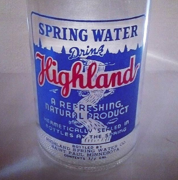
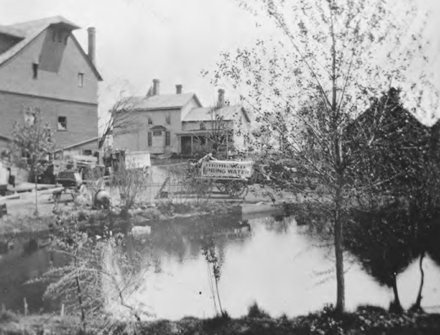
Highland Spring was the most famous bottled spring water in St. Paul (Fig. 1). Established in 1900 by John G. Wardell (1857-1935) on what had been the Nettleton dairy farm, the Highland Spring Water Company continued under son John M. Wardell (1896-1947) and grandson Edward H. Wardell (1917-1999)—the latter known as “Bud”—closing in 1965. The land was redeveloped as Montcalm Estates, a luxury high rise, which after being sold in 2011 was renamed Montcalm Apartments (Sitaramiah 2011). Still and carbonated waters and their derivatives (such as soda pop) were sold in a variety of containers, from single-serving to bulk. Especially the 6-gallon containers delivered to office buildings in downtown St. Paul, the Midway area, and beyond. Ice used to cool the water came from a pond on the property, stored in a three-story icehouse built into the hillside (Empson 1975) (Fig. 2).
Empson (1975) interviewed grandson Bud, his chief informant, ten years after the Highland Spring Water Company had closed. He assumed that the water nowadays seen spouting from the 8-inch standpipe behind the Montcalm Apartments is the namesake Highland Spring, on which the company had built its livelihood (Fig. 3):
“Today the spring is routed into the sewer system, but the curious can walk behind the apartment buildings, and by peering down the manhole grating, see the flow of the spring from the hillside above, running at its constant 27 gallons a minute.”
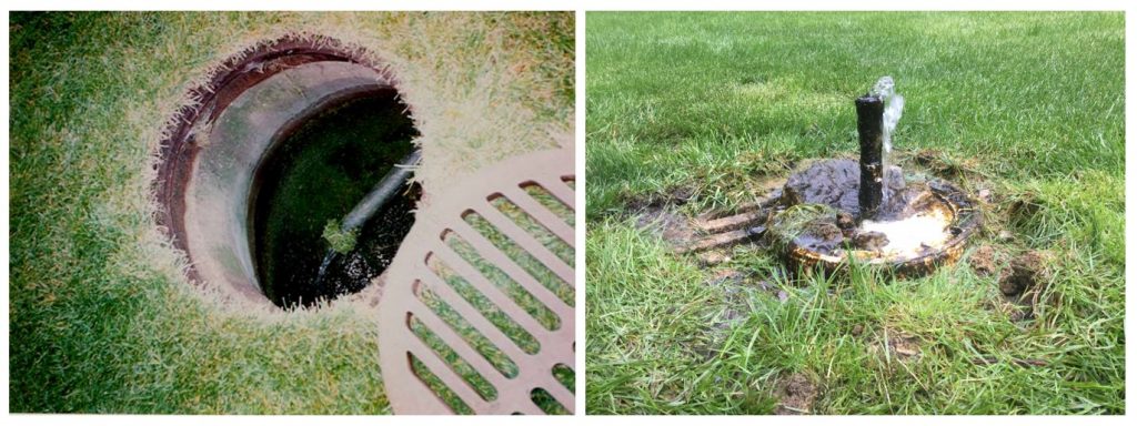
But I recall gazing at this little spring in disbelief. Could it really have supplied an entire city with water? This bathtub faucet looking thing? My gut feeling was that something was terribly wrong. In 2020, I was contacted by Charlie Evans, St. Paul Public Works, who was studying the drainage of the Highland Spring area. This time I decided to probe deeper based on additional records.
But first, my own mea culpa. I had visited this spring during the 1993 Twin Cities spring mapping project (Brick 1997), long before the standpipe was installed, when the spring flowed directly into the storm drain as Empson (1975) described. I also took Bud’s “data” at face value and hadn’t bothered measuring the discharge, which would’ve been so easy to do.
But in 2017, as part of my duties for the Minnesota Spring Inventory at the Department of Natural Resources, I measured the flow rate from the standpipe for the first time, at 3 gallons per minute (GPM), which is equal to 180 gallons per hour (GPH). A quick Google search will tell you that 3 GPM is inadequate to supply even one residential dwelling, let alone a whole city. And it was far less than the expected 27 GPM. Where was the missing water?
The Shallow Wells
I began by revisiting the older geological literature. The geologist George M. Schwartz (1936, p. 120) described two springs at the Highland Spring Water Company: “The larger spring flows about 1000 gallons an hour, and the smaller one about 800.” The combined flow is thus 1800 GPH, or 30 GPM. That was close enough to Bud’s 27 GPM for me to surmise that they referred to the same water source—whatever or wherever it was. It’s interesting that Schwartz gave just one chemical analysis for both springs, however. Perhaps it’s a result of mixing, perhaps they really were identical chemically, or perhaps two separate analyses would have prompted awkward questions. Which was the “real” spring water? Which one was “healthier”? And so forth.1
But where were Schwartz’ big springs nowadays? The notion of a spring or pair of springs flowing about ten times the measured rate of the known Highland Spring struck me as unlikely. I’ve hiked the entire 8-mile length of the “Diamond Necklace” spring-line and all the rest of the springs have a discharge less than 1 GPM (Brick 1997).
However, it’s not certain that Schwartz actually visited the Highland Spring Water Company while compiling his bulletin for the Minnesota Geological Survey. The distinction between springs and wells is clear cut to geologists but not always to laypersons. Perhaps Wardell told him in good faith that they were “springs,” but Schwartz would have recognized them as water wells if he had visited the site himself. Empson (1975), for example, reported that the groundwater supplying the “springs” was flowing at a depth of 20 feet—something that could only be known from water well observations. Indeed, this depth corresponds with the top of the Decorah Shale bedrock at the site (Mossler and Cleland 1992). Accordingly, I surmised that Schwartz’ two “springs” were probably two shallow water wells, about 20 feet deep, tapping the porous glacial sands (Patterson 1992) atop the impermeable shale, and thus separate from the solitary natural spring seen at the standpipe today.
Evans and I scoured the Montcalm grounds for the shallow wells, but found nothing. Nor were they listed in the on-line Minnesota Well Index (MWI), perhaps because of their age, as they could have dated as far back as the American Civil War.2 Thomas Kieffer, the developer of Montcalm Estates, might have shed light on these shallow wells, since he would’ve been the guy to have them sealed, but he passed away in 2018, before I had thought of interviewing him.
But the 2011 real estate transaction should have triggered a Phase I Environmental Site Assessment (ESA) by Gustafson Company, which purchased the property. ESAs will usually contain information on past water wells as well as landowner interviews, as I knew very well from having prepared plenty of them myself as an environmental consultant. Gustafson did not reply to my request for the Montcalm ESA.
However, as a homeowner, I knew about the mandatory well disclosure associated with real estate transfers. Well Disclosure Certificate No. 473012, obtained from the Minnesota Department of Health, revealed the approximate location of the former wells, near the street named Montcalm Place.
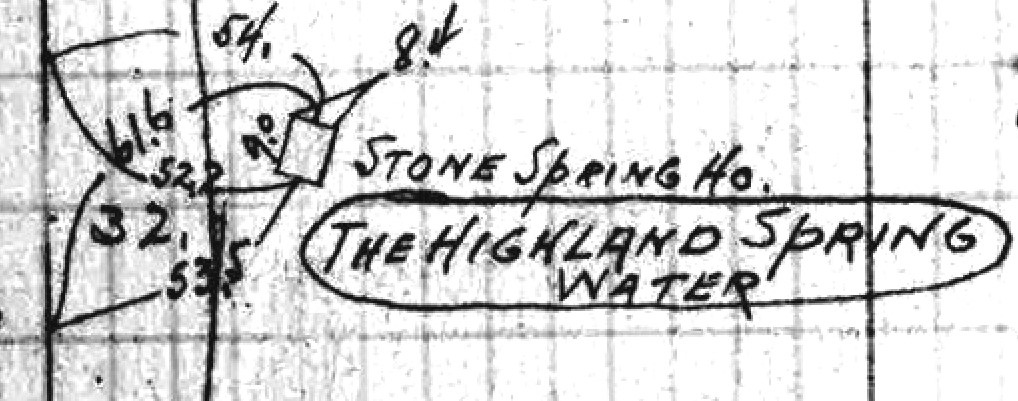
This was corroborated by St. Paul Public Works surveyor’s Fieldbook No. 674, dated 1911, which showed an 8.4 by 9-foot “stone spring house” located where Nettleton Avenue (an unopened street) made a right-angle bend, near the southwestern corner of the property (Fig. 4). Fieldbook No. 358, dated 1927, showed an 18 by 18-foot structure in the same location. So apparently it was enlarged at some point, perhaps when the second well was dug. A stone springhouse that large would’ve been impressive, so it’s unfortunate that no photos of it have yet come to notice. There’s no trace of this structure today on the grassy hillside, but its location, back from the major break in slope on the site (associated with the Decorah edge spring-line) suggests that it was not built around the natural spring itself, but uphill from it, perhaps in a flatter spot. The idea would be to capture groundwater flowing toward the natural spring. Pumping the wells would boost output—enough to account for the “missing water.”
Evans examined Sewer Permit No. 89475, which contained a sketch of the storm drains at the newly constructed Montcalm Estates in 1966. It revealed that what is now the standpipe spring behind the building was the only feature on the Wardell property requiring special drainage. So, there were no other springs lurking about the grounds.3 The presence of this water feature at the major break in slope on the site, marking the edge of the Decorah Shale, corroborates its status as a natural spring (though obviously modified). The shallow wells, by contrast, if properly sealed during redevelopment, would not require accommodation for on-going drainage.
Here I’ll draw a comparison between St. Paul’s and Minneapolis’s best known commercial springs. The original Glenwood-Inglewood Spring was a small spring on the banks of Bassett Creek in Minneapolis. The spring was “improved” by driving pipes down 16 feet and the flow shot up to 10,000 GPH (Schwartz 1936, p. 119).4 If the Highland Spring wells were screened in the glacial sands above the shale, they would’ve been tapping the same water source as the natural Highland Spring itself. A layperson might well argue that it’s a minor, acceptable fudge to call them all “springs” for marketing purposes.
The source of this shallow groundwater deserves comment. The surficial geology plate for Ramsey County (Patterson 1992) was published a generation ago, yet contains a wealth of detail not fully integrated into hydrological explanations for why Highland Spring formed where it did. According to Bud, the “drainage basin” (as he called it) feeding the spring is a rectangular area bounded by Montreal-Saratoga-Summit-Syndicate (Empson 1975). This rectangle partially corresponds with a “former lake” associated with the Grantsburg Sublobe. But in fact, the “clayey lake sediment” which underlies it would impede recharge. A different feature depicted on this same plate which probably exerts more influence on the local groundwater flow is the funneling scarp of a “former drainageway” from the “sandy outwash plain” west of the spring.
But this raises another issue. I’ve personally mapped the springs along the Decorah edge from Montreal to Summit, and to avoid overlap, the Highland springshed would have to be narrower in a north-south direction. Moreover, the named bounding streets don’t reach the obvious height of land (Snelling) which, in the absence of other information, would be its presumed hydrological boundary along the west side. So, the springshed would be elongated in an east-west direction, covering about one half square mile.
Discovery of the Deep Well
The Minnesota Well Index now delivered a bombshell. Having queried the database unsuccessfully for the shallow wells, it revealed something quite unexpected. Keys Well Drilling Company had installed a water well 492 feet deep, screened in the Jordan Sandstone, in 1961, explicitly for commercial use by the Highland Spring Water Company (Unique Well ID: 200413). This well was fitted with a 7.5-horsepower submersible pump rated at 50 GPM. The whereabouts of this deep well on the property was unknown, however, since MWI had assigned a generic location based on street address. I assumed the deep well was still in existence, however, as the cost of installation is high and they remain valuable assets.
Evans and I contacted Adam Schreiner, maintenance engineer at Montcalm Apartments. He showed us around and shared Kieffer’s blueprints. He revealed that the deep well was under the manhole in front of the 515 wing of the building, which I personally verified on June 18, 2021, when the water well was serviced by McCarthy Well Company (Fig. 5). At that time, the well pump was being replaced. But the well water is no longer used for drinking purposes, it is circulated through the high rise building for cooling purposes, he told us.
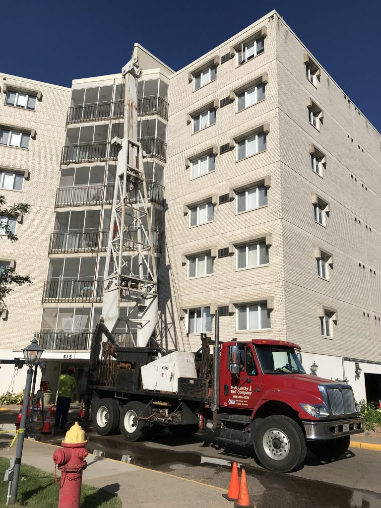
The conclusion was now water-tight: the Highland Spring Water Company never sold spring water. It was all just well water. At first from the shallow wells and later from the deep one.
“The Springs are Petering Out”
Evans put me in touch with Herbert Cook, Jr., a 92-year-old former employee of the Highland Spring Water Company who held a seasonal job there during his high school years (mid 1940s). We interviewed Cook, who lived in a house across the street from Montcalm, on October 16, 2020. Cook provided some long overdue, unfiltered insight into company history.
The overall impression we got was that the Wardell’s were a resourceful family who successfully adapted to circumstances. Cook stated that he was primarily involved with cutting ice on their pond in winter. Water to fill the pond was obtained, not from “the abundant spring,” as might be expected, but from a garden hose connected to city water. Inside the bottling shed, he recalled, empty containers were placed in an 8-foot-long trough and manually filled from taps. The pipes made noisy clanking sounds as the pumps started up. Only later was bottling machinery employed. Under close questioning, however, Cook did not recollect seeing the actual source of the “spring” water used to fill the bottles.
Frank A. Kohout (1889-1957), superintendent, ran the operation during these years, along with Bud Wardell. One of them informed Cook that “the springs are petering out,” probably because Highland Park was becoming increasingly paved over and urbanized, decreasing recharge to the shallow glacial aquifer that fed the “springs.” Living in the same neighborhood for many years after his employment, and staying in touch with management, Cook was aware of the deep well when we asked him about it, stating that it had been drilled to boost output. Bud left Empson (1975) with the impression, by contrast, that the “springs” had “a constant flow” that continues even today. Was this just Bud’s time-worn sales pitch when talking to strangers?
It may be more than a coincidence that the year the deep well was drilled, the Cold War was heating up. During the 1961 Berlin Crisis and the 1962 Cuban Missile Crisis, American citizens were urged to stockpile food and water (George 2003, p. 78). Two neighborhood residents independently told me they had stockpiled bottled water from Highland Spring during these troubled years, and one of them (Kate Walters) donated two unopened half-gallon bottles to me, which I was planning to have analyzed for tritium. But given the revelation described above, I don’t know whether this water came from the shallow aquifer, the deep aquifer, or both. So, any interpretation would be moot.
The Company Dissolved
In 1975, Bud claimed that the Highland Spring Water Company was dissolved because “the business of deriving a livelihood from a spring in a totally urban area had become a rather chancey one. A break in the sewer, an excavation in the wrong place, pollution in any form, and the company would be out of business overnight” (Empson 1975). But this seems like hindsight. While it’s common for companies to call it quits after a disaster, it seems odd to quit before one takes place, especially before widespread public concerns about pollution, before events like the Love Canal disaster. Indeed, its “sister spring,” Glenwood-Inglewood, thrives in Minneapolis to the present day, with hazardous waste sites nearby. Most importantly, the Wardell’s had just recently installed a costly deep well, which would help them avoid the surficial contamination the natural spring was threatened by.5 Perhaps any reassurance for customers about the healthfulness of their “spring” water would entail admission that they were actually drinking well water—albeit from a deep, secure source.
An alternative motivation to shut down, mentioned in passing by Empson (1975), is that the land had become “a piece of choice real estate with a commanding view.” This seems much more plausible to me.
Another coincidence, not hitherto considered with regard to Highland Spring, is worthy of discussion. Upon passage of the Federal Food, Drug, and Cosmetic Act (FFDCA) in 1966, the Food and Drug Administration began to regulate bottled water as a food. The word “spring” acquired a specific legal definition for bottling purposes. The Code of Federal Regulations, Chapter 21, Part 165.110(a)(2)(vi) states:
“The name of water derived from an underground formation from which water flows naturally to the surface of the earth may be “spring water.” Spring water shall be collected only at the spring or through a bore hole tapping the underground formation feeding the spring. There shall be a natural force causing the water to flow to the surface through a natural orifice. The location of the spring shall be identified. Spring water collected with the use of an external force shall be from the same underground stratum as the spring, as shown by a measurable hydraulic connection using a hydrogeologically valid method between the bore hole and the natural spring, and shall have all the physical properties, before treatment, and be of the same composition and quality, as the water that flows naturally to the surface of the earth. If spring water is collected with the use of an external force, water must continue to flow naturally to the surface of the earth through the spring’s natural orifice.”
It’s obvious that the Highland Spring Water Company could not comply with the 1966 statute. Because the Jordan Sandstone—which now provided the bulk of the company’s water—is not “from the same underground stratum” nor does it have “a measurable hydraulic connection” with the spring-bearing surficial glacial sands hundreds of feet above it, they could no longer market their product as “spring water” without violating the statute. It must now be labeled “well water” or other. And “Highland Well” would have far less cachet than “Highland Spring.” Whether merited or not, calling something a spring confers higher status than calling it a water well, in folk hydrology.6 Perhaps the Wardell’s anticipated this dilemma and decided to close up shop?
Conclusions
In summary, the “secret history” of the Highland Spring Water Company (1900-1965) reveals that its commercial water supply was derived from surficial water wells during most of its existence and when these “springs” began “petering out” during the surge in demand resulting from Cold War stockpiling, from a deep bedrock well. The company closed for a combination of possible reasons such as subsequent drop in demand, the advent of Federal labeling requirements, and tempting real estate values. While there’s an (apparently) natural spring on the site today, flowing at 3 GPM—one link in a well-known spring-line along the Decorah edge—this spring never played a role in commercial operations apart from lending its name to the company. About the only water it ever provided was for Nettleton’s dairy cows in a past century. The origin of the assertion that the business was based on springs was likely two-fold, namely the layperson’s confounding of springs and wells, and because the word spring confers higher status than the word well when marketing bottled waters. But this threadbare advertising hype has misled people for too long.
The natural spring water originates from the focused discharge of a sandy outwash plain, not a former lake basin. The supreme irony of the Highland Spring Water Company is that given this shallow glacial aquifer in an urban area, the Jordan well water was likely of much higher quality and much less vulnerable to contamination than the shallow “springs” they clung to so tightly. And if the Wardell’s had hung on a few more years, until the late 1970s, using a more nuanced labeling, the company’s fortunes would likely have rebounded with the resurgence of the single-serving market (Chapelle 2005, p. 120). They might have basked in the glory of a second golden age, with the deep well and appropriately labelled products. Whether that, too, would’ve been swept away by a later wave of soaring real estate values, is another question.
You need only look at the popularity of the Schmidt Brewery wellhouse with its vending machines, about one mile away, to see what a mania there is for drinking bottled water today. However, there never was a natural spring at Schmidt, and the owners seem to be making the implicit argument that the depth of the well is a proxy for purity (it terminates at 1050 feet in the Mt. Simon-Hinckley aquifer, according to MWI). Hence the image of the mammoth on their signage with the explanation that the water entered the ground 30,000 years ago, during the last ice age, evoking a pristine world.
Due Diligence Statement
I made efforts to solicit input from living Wardell descendants for this story on various Facebook groups. As for newspaper research, neither Empson nor the present writer have been able to locate any substantive, in-depth coverage about Highland Spring during its heyday, but it should exist, and could provide additional insights. Even some of our lesser-known local springs like Frederick Miller Spring in Eden Prairie, seem to get more press coverage by comparison. Unfortunately, the period of the company’s existence (1900-1965) corresponds with a huge indexing gap for the St. Paul newspapers. I’ve spent many frustrating hours at microfilm readers!
Acknowledgements
Peggy Bremer, Gary Brueggemann, Herbert Cook Jr, Patricia Davis, Don Empson, Charlie Evans, Russ Hanson, Jim Lamoreaux, Mary Ann Miller, Adam Schreiner, Kate Walters.
Notes
- The water analysis provided by Schwartz (1936) differs from Empson (1975), indeed, they appear to be two different waters. The latter-day waters are much harder with a different calcium: magnesium ratio, suggesting a different groundwater flow path.
- The Hatch house (1863-1876) briefly occupied the site about the time that Nettleton purchased it in 1871. This former Italian villa style mansion was said to include “attic tanks that supplied water (piped in from springs on the property) to the bathrooms and kitchen” (Millett 2011, pp. 136-137). As will be seen, the word “springs” is often used loosely in such informal contexts.
- For years I suspected there might be “lost springs” at Montcalm Estates, buried during the construction of the high rise, manifesting themselves by overworked sump pumps inside the basement. While proving illusory, these lost springs could have supplied the “missing water” for the hydrological balance sheet!
- Winchell (1905) reported 10,000 gallons per day (GPD) for the Glenwood Spring, rather than 10,000 GPH. I don’t know which one is correct, but it goes to show how a 24-fold difference in discharge can easily go unnoticed on paper!
- While no water samples were analyzed from Highland Spring in 2017, its temperature was measured as 54 °F, whereas Bud reported 42 °F (Empson 1975). A warming of 12 degrees Fahrenheit is a sure sign of human impacts. The spring is running a fever!
- The practice of deliberately confounding natural springs with drilled wells flourished at America’s first and for many years most famous spa, Saratoga Springs, in upstate New York (Davis and Davis 1997).
References
Brick, G.A. (1997). Along the Great Wall: Mapping the Springs of the Twin Cities. Minnesota Ground Water Association Newsletter 16(1): 1-7.
Brick, G.A. (2007a). The Highland Park Spring Water Company. Minnesota Ground Water Association Newsletter 26(2): 13-14.
Brick, G.A. (2007b). St. Paul’s Diamond Necklace. Minnesota Ground Water Association Newsletter 26(3): 15-17.
Chapelle, F.H. (2005). Wellsprings: A Natural History of Bottled Spring Waters. New Brunswick, NJ: Rutgers University Press.
Davis, S. N. and A. G. Davis (1997). Saratoga Springs and early hydrogeochemistry in the United States. Groundwater 35(2): 347-356.
Empson, D.L. (1975). History Resided at Nettleton-Wardell Home. St. Paul Dispatch, March 4, p. 10.
Empson, D.L. (2017). William Nettleton, John G. Wardell, and the Highland Spring Water Company in St. Paul. Ramsey County History 52(2): 18-22.
George, A.L. (2003). Awaiting Armageddon. Chapel Hill: The University of North Carolina Press.
Millett, L. (2011). Once There Were Castles: Lost Mansions and Estates of the Twin Cities. Minneapolis: University of Minnesota Press.
Mossler, J.H. and J.M. Cleland (1992). Depth to Bedrock Map. Geologic Atlas of Ramsey County, Minnesota. County Atlas Series, Atlas C-7, Plate 5. St. Paul, MN: Minnesota Geological Survey.
Patterson, C.J. (1992). Surficial Geology. Geologic Atlas of Ramsey County, Minnesota. County Atlas Series, Atlas C-7, Plate 3. St. Paul, MN: Minnesota Geological Survey.
Schwartz, G.M. (1936). The Geology of the Minneapolis-St. Paul Metropolitan Area. MGS Bulletin 27. Minneapolis: University of Minnesota Press.
Sitaramiah, G. (2011). Highland Park’s Montcalm Estates sold locally. St. Paul Pioneer Press, June 24.
Winchell, N.H. (1905). Deep wells as a source of water supply for Minneapolis. American Geologist 35(4): 266-291.
MGWA is committed to developing a just, equitable, and inclusive groundwater community. Click on the button below to read MGWA’s full diversity statement.