By Philip Margarit1, Leslie Ludtke1, Joe Magner2, John Nieber2
1University of Minnesota, Twin Cities Water Resources Science Program, 2University of Minnesota, Twin Cities Bioproducts and Biosystems Engineering
Much of northern Minnesota resides in 1855 Treaty territory, including the Pineland Sands Aquifer System in the Upper Mississippi Headwaters Region which is important economically, culturally, and ecologically. The 1855 Treaty Territory encompasses federally protected resources and homelands of the Anishinaabe Peoples, as well as numerous high-valued resources such as trout streams and wild rice water bodies.
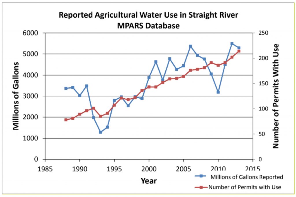
The Pineland Sands Aquifer System, located within Becker, Cass, Hubbard, and Wadena Counties, is an important source of groundwater resources for agriculture, human use, and baseflow in important watersheds of the Upper Mississippi Region such as the Straight River and Crow Wing Watersheds. The Pineland Sands Aquifer System consists of glacial aquifers and aquitards of sands and tills. The sands aquifers of the aquifer system are characterized as being highly transmissible. This creates a substantial risk for contamination of the groundwater resources in the region with land use management driving the quality and quantity of the region’s water resources. In the early 1800s, the region was covered with dense forests and native plants such as forbs and grasses. In 1888 after commercial logging in the area had cleared much of the native forests, the area was described as becoming rapidly cultivated. In the present day, the area is now home to thousands of acres of agricultural fields, with hundreds of high-capacity public and agricultural wells extracting groundwater from the underlying Pineland Sands Aquifer System. Agricultural water use and numbers of irrigation permits have been steadily increasing since the 1990s (Figure 1).

In addition to groundwater extraction, fertilizer loading in the region has become a concern with the Straight River being listed as an impaired water body for aquatic life due to low dissolved oxygen levels. This has been found to be caused by high levels of algal stimulating nutrients and increasing temperatures from reductions in groundwater discharge into the river due to irrigation This impairment caused the creation of the Straight River Groundwater Management Area by the Minnesota Department of Natural Resources (MNDNR, 2017). In addition, numerous private wells in the region have been found to be contaminated with nitrate above the 10 mg/L health standard, as well as pesticides being detected in private wells sampled for pesticides from 2017-2018 in Becker, Hubbard, and Wadena counties in 46%, 57%, and 85% of wells respectively during the Private Well Pesticide Sampling Project (Schaefer et al., 2022). Recently, the City of Park Rapids had to install a new municipal well and nitrate treatment system to help resolve its high nitrate problem. As a result, fees for city water use went up by about 25% (Gunderson, 2014).
Due to the increasing agricultural activity of the region, the Anishinaabe Peoples have developed concern over the impacts of this activity on the water quality and quantity of the Pineland Sands Aquifer System and the surface water bodies for which groundwater constitutes a significant fraction of the water balance. Preserving the water quality and quantity of the region’s water resources is of critical importance to the Anishinaabe since wild rice grows naturally within the region. Wild rice, also referred to as manoomin by the Anishinaabe, is culturally and spiritually significant, as well as economically important for their local communities. In addition, trout and endangered mussel populations home to the region are just some of the biota threatened by changes in the quality and availability of water in the water bodies in which they reside.
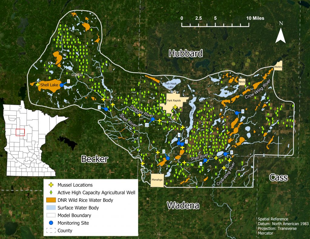
Our study area comprises approximately 346,000 acres of the northern portion of the Pineland Sands Aquifer System and is located within the Crow Wing Watershed in the Mississippi Headwaters. Within this study area, there are approximately 402 active agricultural irrigation wells that extract over 5 billion gallons of groundwater annually from the aquifer system.
The hypotheses of the study are firstly, that current intensive irrigation within the study region likely exceeds ecosystem resilience and is not sustainable into the future. Second, we hypothesize that groundwater pumping and agricultural activity in the region has and will continually impact streamflow and water quality and that these impacts will adversely influence native plants and animals such as wild rice. Lastly, we hypothesize that sustainable land management practices that do not adversely impact the physical, chemical, and biological integrity of surface and groundwater must include greater crop diversity and more robust soil health. The objectives of this study will be completed with a combination of modeling and field efforts. The modeling will integrate model output from Soil Water Assessment Tool (SWAT), a land surface hydrologic/water quality model into the inputs (groundwater recharge and contaminant loading rates) for the groundwater model, MODFLOW. MODFLOW groundwater models are being developed utilizing geologic data from the Minnesota Geological Survey (MGS), well location and pumping rates data from the Minnesota Department of Natural Resources (MNDNR), well water level data from the Minnesota Department of Health (MDH), and surface water data from the MNDNR. A suite of MODFLOW models are being developed using a telescoping approach, ranging from a large regional groundwater model for the northern Pineland Sands Aquifer System, to catchment scale models and site-scale models in the region.

The two current models in development at this stage of the project are the regional model and a Straight River catchment scale model. Paired SWAT Models are additionally being developed for the catchment scale and site scale MODFLOW model areas. MT3DMS will be employed with the resulting MODFLOW simulations for contaminant transport modeling throughout the study.
The suite of models that will be constructed as a result of this study will be used for scenario based modeling experiments to investigate the impact of land use changes such as changes in groundwater pumping rates, changes in groundwater recharge rates, the impacts of land use changes on water resources from pre industrial agricultural conditions to post agricultural conditions, and the differences between current agricultural land use management and hypothetical regenerative agricultural land use management proposed by the Anishinaabe Agricultural Institute on water resource impacts. The use of SWAT and MODFLOW will allow for the quantification of impacts on both surface and subsurface water resources.
In order to aid the modeling efforts of this project, field work will be completed at three different scales; field, watershed, and regional. At the regional and watershed scales, rating curves and base flows of the major rivers in the model area will be measured and determined through the use of water level loggers, monthly flow sampling, and existing DNR and MPCA cooperative stream gaging stations. The three big rivers in the model area are the Straight, Shell, and Crow Wing. In addition to flow data, water quality samples will also be taken from the rivers in various locations around the model area. The analytes to be analyzed from the samples taken monthly include major anions and cations, such as phosphorus, nitrate, and sulfate, as well as the stable isotopes of O-18 and Deuterium, and major pesticides known to be used in the area.
The field scale study will be conducted through the close working relationship with the Anishinaabe Agricultural Institute on one of their newly acquired center pivot irrigated fields. A Soil-Water-Balance model will be developed across their multi-crop field through the use of soil moisture sensors and a complete weather station. And soil health will also be analyzed under the different crops and practices to help determine the most sustainable land management practices for the area. By looking at soil pore water, shallow groundwater, and deep groundwater within the area, we will be able to better understand the region’s hydrologic cycle. Water quality and quantity data collected will help with model calibration and scenario based modeling experiments.
Initial modeling and field work has been conducted on this project over the past year and the rest will be completed over the next three years. This multifaceted project will be a combined effort between researchers at the University of Minnesota, the Anishinaabe Agricultural Institute, and the White Earth Nation. Dr. Joe Magner and Dr. John Nieber are leading the field and modeling efforts respectively at the University of Minnesota and have integral parts in creating the project ideas presented in this article. The outcome of this project will result in better information about the sustainability of agricultural practices on groundwater within the Pineland Sands Aquifer System.
References
Gunderson, D. (2014, January 143). Irrigation boosts potatoes, but Park Rapids pays more for water [Radio broadcast transcript]. MPR News. https://www.mprnews.org/story/2014/02/13/ground-level-beneath-the-surface-park-rapids
MNDNR. (2017). Straight River Groundwater Management Area Plan. https://files.dnr.state.mn.us/waters/gwmp/area-sr/sr_gwma_plan.pdf Schaefer, B., Bruening, B., Johnson, H., Meyer, R., & VanRyswyk, B. (2022). Private Well Pesticide Sampling Project. https://wrl.mnpals.net/islandora/object/WRLrepository%3A3867
MGWA is committed to developing a just, equitable, and inclusive groundwater community. Click on the button below to read MGWA’s full diversity statement.